


Community Plan Area 5/ Special Policy Area #8 Secondary Plan
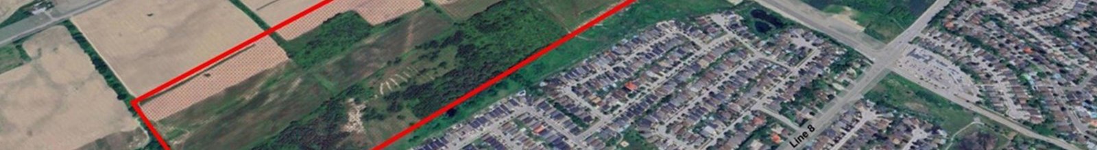
The lands north of the proposed Bradford By-pass and South of Line 9 are known as Community Plan Area #5 or Special Policy Area#8, and represent the last Community Plan Area identified in the Town’s 2002 Official Plan for development in the Bradford Urban Area. The lands are generally located along Line 9, north of the Highway 400-404 Link and west of Artesian Industrial Parkway.
What is a Secondary Plan?
A Secondary Plan is required, as per the Official Plan, prior to any development proposals being implemented. The purpose of a Secondary Plan is to provide land-use policies and guidelines tailored to the subject area, which will manage and direct the future growth and development expected to occur on these lands.
This Secondary Plan process is initiated by the Bradford CP5 Developers Group Inc. and led by a team of consultants in collaboration with the Town.

Maps
| CPA5 Boundary Delineated as North of the Bradford By-pass |
|
|
| CPA5 Now Known as SPA8 |
|
|


Get Involved!
Submit your email to the subscribe button in the top right corner of this page (if on desktop) to be notified of all updates regarding this study, or email Thomas Dysart.
Review the Draft Studies
The project team’s consultants have submitted Draft Studies for initial review; these studies are a follow up to feedback from residents which was heard at the January 2025 Open House. These Documents will be available soon and uploaded as soon! For immediate information, please contact Thomas Dysart.
Plan Process
Below if an overview of the process.
We are currently in Phase 2.
| Terms of Reference (Q1-Q2 2024) |
|
The Terms Of Reference for the Special Policy Area 8 (formerly known as Community Plan Area 5) was approved by Council on June 18, 2024. The Terms of Reference outlined the proposed work plan which is divided into four (4) specific Phases. |
| (Q2 2024-Q1 2025) |
Existing conditions and technical background studiesThe purpose of Phase 1 is to complete a review to understand the existing land use context and fabric of the study area including the areas outlined below:
|
| WE ARE HERE Phase 2 (Q1 2025-Q3 2025) |
| Visioning, Objectives and Targets
The purpose of Phase 2 is to begin drafting secondary plan land use maps to visualize and understand
|
|
Phase 3 (Q3 2025-Q2 2026) |
| Develop Draft Secondary Plan The purpose of Phase 3 is to create a Secondary Plan that illustrates and considers all components of studies and feedback through Phases 1-2 to guide development patterns.
|
| Phase 4 (Q2 2026-Q3 2026) |
| Finalize Secondary Plan The final phase of the secondary plan process will establish the final Secondary Plan in which future growth and |
Contact Us